In light of Metro's series of
workshops on their Master Plan for Union Station, I thought it would be nice to really take stock of what the future holds for the centerpiece of Los Angeles' rail and bus network.
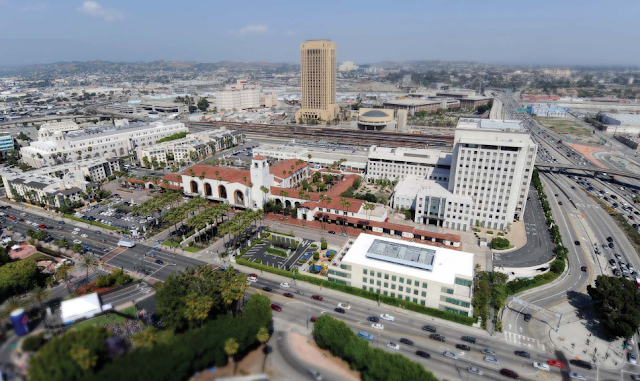 |
| Union Station, as it appears today. |
 |
| A breakdown of the property included in the study. |
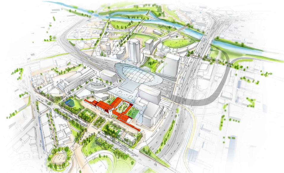
Metro has made it clear that transit will be the main emphasis of this study, but the future of Union Station also holds implications for the surrounding neighborhoods. From a developer's standpoint, there is a lot of land potentially up for grabs depending on the options chosen.
Based on the presentation given yesterday evening (the recorded version of which can be viewed
here), Metro seems to have narrowed down the massive re-model/expansion to two basic alternatives.
Both of these alternatives involve some much needed aesthetic changes to the Alameda fronting side of the property, as seen here:
As you can see from the diagram, Metro is re-activating much of the underutilized space within the station itself. The beautiful Ticketing Hall, which currently sits vacant, would be filled with retail and restaurant space. The surface parking lot in front of the building would be replaced with public green space. This makes Union Station more accessible from Alameda, while also taking away the irony of a large parking lot sitting in front of Los Angeles' regional transit hub.
The phased closure of Los Angeles street unifies Los Angeles Plaza Park, Olvera Street and El Pueblo, allowing the combined neighborhood to organically feed into the station's front door. Closure of the street may also mean the elimination of the existing freeway on-ramp, which potentially opens up the restored parcel of land for development. Alameda also receives streetscape improvements, which would make the pedestrian connection running into the Civic Center and Little Tokyo much more pleasant (it currently resembles something out of a Mad Max movie). The streetscape improvements would also make a nice transition between Union Station and the
future Park 101.
But enough about grass and pedestrian connections. What about the real meat of the Union Station re-model? Both of the refined alternatives include relocation of the bus terminal from Patsaouras Plaza as well as a realigned and expanded passenger concourse. The two options can be seen here:
The left side, which I will refer to as "Alternative A," moves the Bus Terminal north of the station building, onto the site currently occupied by the Mozaic Apartments. The expanded Passenger Concourse occupies the space in between the station building and the train yard, which is currently a parking lot. The right side, a.k.a. "Alternative B," locates the Bus Terminal to the space between the train yard and the station building, while expanding the existing tunnel beneath the tracks into a much larger and amenity laden passenger concourse. Let's take a look at the details of each option.
Alternative A
 |
| Overhead diagram of Alternative A |
As previously mentioned, Alternative A's Bus Terminal is relocated north of the station building, with access provided from both the El Monte Busway on the south and Caesar Chavez Ave. on the north. The Passenger Concourse is two levels, covering the area from the Bus Terminal to the Metropolitan Water District Headquarters. Access to the train platforms is provided by parallel bridges running over the train yard. This alternative opens up several parts of the station for development, including the small parcel adjacent to MWD HQ, a parcel across the Eastern Entrance from Metro HQ, above the two story Bus Terminal, and room for an on-site hotel next door to the old Ticketing Hall. Now how about some eye candy?
 |
| Concept drawing for Alternative A's passenger concourse. Lots of open space with some retail kiosks dispersed throughout. The all-glass ceiling makes for nice views of the surrounding development and exposure to all the LA sunshine you could ever want. Seriously though, I think some shade might be in order here. |
 |
| Alternative A, viewed in profile from the directly west. The canopy above the train yard may prove infeasible depending on how California High Speed Rail chooses to enter Union Station. |
 |
| Bird's eye view of Alternative A. You can see the future Union Station run through tracks over the 101 outlined here. This alternative also includes a pedestrian/bicycle bridge to the Art's District (it's the twisty white line crossing over the Gold Line tracks). Not sure how hospitable an environment that makes for, considering it would be crossing over a freeway. |
Alternative B
 |
| Overhead diagram of Alternative B |
Alternative B's Bus Terminal sits where Alternative A's Pedestrian Concourse would stand. Alternative B's Passenger Concourse takes advantage of the existing tunnel underneath the train yard, but greatly expands upon its footprint. One thing is for certain: this option does not scrimp on the retail. I see it written everywhere in the diagram. Alternative B also offers several opportunities for development, but that comes later. Now, more eye candy:
 |
| Artist's concept of Alternative B's Passenger Concourse. The main corridor is reserved for pedestrian flow, with escalators up to the platforms. To the left we see an area which has been lowered to provide seating and space for (you guessed it) even more retail. This version of the Passenger Concourse also allows for openings to the train yard above to provide direct sunlight. While I enjoy the concept, I hope they cover those openings with glass. It does (occasionally) rain in Los Angeles, which would make for a very messy situation on bad weather days. And unless Metrolink and Amtrak are planning for complete electrification sooner rather than later, fumes from diesel locomotives could be an issue. |
 |
| Alternative B, viewed from its western profile. Interestingly, they've included a canopy over the train yard here (perhaps to deal with the bad weather I was griping about in the previous caption). Once again, depending on CAHSR's interaction with LA Union Station, I'm not sure if a canopy is feasible. |
|
 |
| Alternative B from the bird's eye view. The pedestrian/bicycle bridge is not present in this option. Alternative B loves open air, but it hates bicycles and pedestrians on bridges! |
So where does that leave us?
The Bus Terminal placement seems immaterial, since both alternatives provide access to Caesar Chavez Avenue and the El Monte Busway. Both alternatives also provide substantial development opportunities, but that shouldn't be the focus here. Making the best Union Station isn't about maximizing the available FAR.
So then it comes down to the Passenger Concourse, in which case I have to give it to Alternative B. Pedestrian movement is already focused down the tunnel running beneath the tracks. It makes sense to expand on an area where the people already have to go.
If you want to get coffee at Union Station before catching your train, you currently have one convenient option: the Starbucks in the Waiting Hall. After that, you still have to walk (or possibly sprint like a maniac) down the tunnel to make your train. At rush hour, this involves dodging hundreds of fellow travelers and the occasional handicap transportation cart. Having a waiting area adjacent to your station platform makes for a much more leisurely passenger experience, while avoiding the forced pedestrian bottleneck. Alternative A is aesthetically appealing, but doesn't offer that improved passenger experience. Philosophically, it's an expansion of the existing situation, albeit with multiple pedestrian corridors instead one just one.
All of these changes are years (decades?) off, but it's still fun to imagine for now.
 |
| The giant letters may or may not be part of the final plan. |